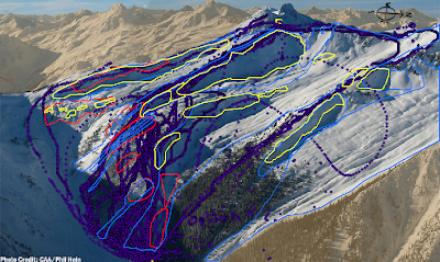
 map 1: My test subjects had to draw a 'safe' backcountry route from points A-B (obscured) through avalance terrain.
They did this 3 times (in b/w other activities).
This map displays the distribution of their 1st attempt .
Yellow polygons= loaded areas; Blue= avalanche paths; Red= terrain traps
Some of them obviously didn't try or are really, really out to lunch.
 map 2: Location of all terrain hazards (loaded areas, avalanche paths, and terrain traps) overlain onto a density map of the routes in map 1
 map 3: Terrain trap polygons overlain onto a density map of user's 1st routes. The yellow line is the actual route you should take from A-B (drawn by one of the avalanche experts I worked with). They averaged hitting 2 traps, which itself isn't too bad. However, hazards often overlap which leads to a higher risk of initiating an avalanche.
Ranae's overlapping days and nights of work also contribute to an increased risk of becoming even more lame.
on that note, now i must decide if i should go home to bed or the brickhouse for a nitecap....hmmm......
1 comment:
I'm always afraid to admit it to you, but I doubt I would do very well finding a safe backcountry route.
Post a Comment